Skip to product information
1 of 2

GNSS Hi-Target V700S SLAM RTK

GNSS Hi-Target V700S SLAM RTK

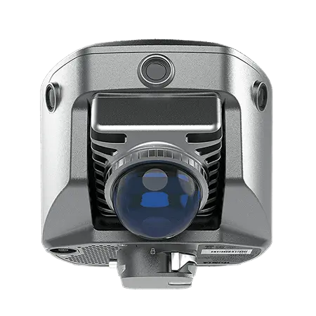
Hi-Target V700S SLAM RTK is a compact, lightweight surveying system with secure screw-lock battery connection, featuring contactless measurement (5cm accuracy, 2~15m working distance) via laser point cloud and image tech for complex areas like tunnels; it supports 1408-channel full-constellation GNSS, built-in IMU tilt survey, and pairs with an 8-inch rugged Android 10 tablet (8-core, 8200mAh) plus Hi-Survey/Hi-LiDAR software, with IP64 protection and multi-mode connectivity (4G/Wi-Fi/UHF) for urban renewal, tunnel surveying and more professional tasks.

Contact us for the best deal on this product.

Quantity

Specifications

  • GNSS: 1408 channels, supports GPS/BDS-3/GLONASS/Galileo/PPP/SBAS
  • Positioning Accuracy: RTK (8mm+1ppm H/15mm+1ppm V), static (2.5mm+0.1ppm H), image measurement (5cm)
  • Laser Scanner: 0.1~70m range, 200k pts/sec rate, Class 1 eye-safe, 360° H FOV
  • Hardware: Φ134.4×109.9mm, 1.68kg, IP64, 2.8-inch touchscreen, -20~+55℃ operating temp
  • Power/Storage: 512GB ROM, 45W fast charge; built-in (4hrs RTK/2hrs SLAM) + external (10hrs RTK/5hrs SLAM) battery
  • Communication: Wi-Fi 6, Bluetooth 5.2, UHF (410~470MHz), USB-C, Nano SIM

Features

  • Full-constellation GNSS + PPP for versatile high-precision positioning
  • SLAM laser/image tech for contactless measurement in tunnels/culverts (5cm accuracy)
  • Real-time volume calculation & precision heat map monitoring
  • AR stakeout + single-photo multi-point coordinate acquisition
  • Compatibility with Hi-Survey (field) & Hi-LiDAR (post-processing) software
  • Rugged IP64 design + dual battery options for harsh field use
  • Remote services (online upgrade, remote control) for seamless maintenance

Download Brochure

View full details